 Catalalogue de l'ORE OMERE
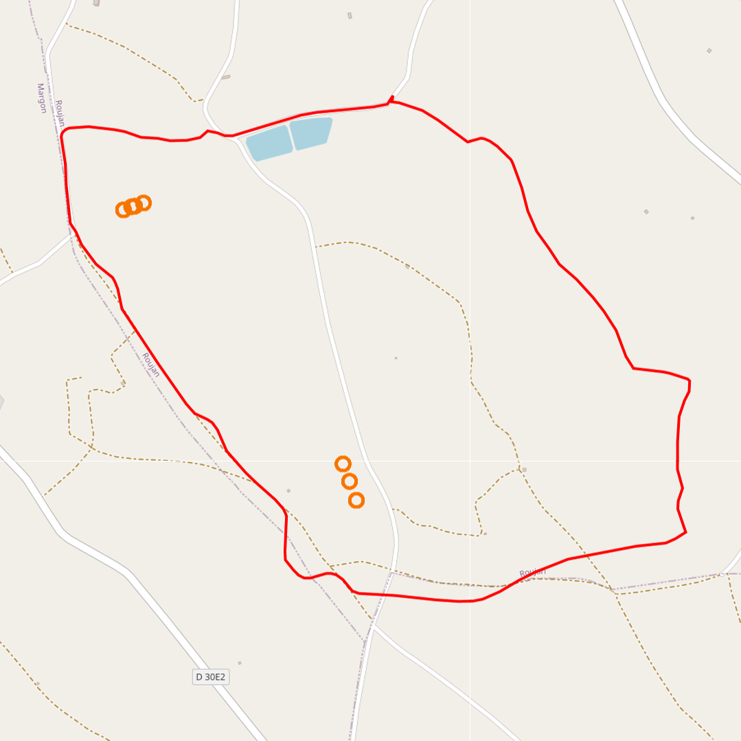
Soil texture analysis (Roujan)
The thematic map provided allows you to visualise the measurement points concerning this data acquisition device. This map is accessible via a standardised WMS flow, but also enables the data sets associated with the measurement point to be downloaded, depending on the case, via the ORE OMERE data portal.
Simple
- Date ( Creation )
- Date ( Publication )
- Date ( Revision )
- Status
- On going
Custodian
INRAE - GC
-
Roujan site manager
(
Administrateur du Système d'Informations
)
https://www.umr-lisah.fr/?q=fr/content/c-coulouma
2, place Pierre Viala
,
Bâtiment 24
,
Montpellier
,
34060
,
France
+33499613074
https://www.umr-lisah.fr/?q=fr/content/c-coulouma
Principal investigator
ORE OMERE
-
Scientific Coordinators
(
Scientific coordination of the Observatory
)
2, place Pierre Viala
,
Bâtiment 24
,
Montpellier
,
34060
,
France
https://www.obs-omere.org/fr/organisation
- thesaurus_localisation_omere ( Place )
-
- Roujan
- GEMET - INSPIRE themes, version 1.0 ( Theme )
-
- Environmental monitoring facilities
- theme.hydrology_unesco.rdf ( Theme )
-
- Hydrological networks
- Hydrology
- Fluid mechanics
- Hydrological measurement
- Hydrological research
- Water resources
- Groundwater
- Earth sciences
- Water balance
- Hydrological cycle
- Surface water
- Hydrology education
- UNESCO Thesaurus UNESCO Thesaurus ( Theme )
-
- Soils
Resource constraints
- Access constraints
- Intellectual property rights
- Use limitation
- Free use subject to compliance with the OMERE Observatory data use charter available on this form and also digitally signed when downloading data via the OMERE portal.
- Description
- Roujan
N
S
E
W
))
- Distribution format
-
-
utf8
(
1
)
-
utf8
(
1
)
- OnLine resource
- Roujan data portal ( WWW:LINK-1.0-http--link )
- OnLine resource
- Charter for the use of OMERE Observatory data ( WWW:LINK-1.0-http--link )
- OnLine resource
-
roucnt21311_l93
(
OGC:WMS-1.3.0-http-get-capabilities
)
Geographical layer of the contour of the Roujan catchment area
- OnLine resource
-
fr_texture_sol
(
OGC:WMS-1.1.1-http-get-capabilities
)
Geographical layer of soil sampling points for textural analysis.
- File identifier
- 79b6146e-3ff3-418d-bf60-898a554da4ff XML
- Metadata language
- fr
- Parent identifier
- Observation site of the Roujan's catchment (Herault / France) 1c37c878-e4cc-4137-8556-11561b4d91a1
- Date stamp
- 2021-04-09T14:00:01
Custodian
INRAE - AD
-
Arnaud DUBREUIL
(
Information System Administrator
)
https://www.umr-lisah.fr/?q=fr/content/a-dubreuil
2, place Pierre Viala
,
Bâtiment 24
,
Montpellier
,
34060
,
France
+33499612347
https://www.umr-lisah.fr/?q=fr/content/a-dubreuil
Overviews
thumbnail4647540446522390932.png

Spatial extent
N
S
E
W
Provided by

Associated resources
Not available