 Catalalogue de l'ORE OMERE
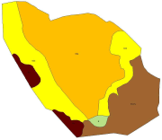
Geological map - Roujan Site
Geological map of the Roujan catchment area ( 1/5000 scale), modified from the official BRGM geological map (1/50000 printed map number 1015)
Simple
- Date ( Creation )
- 1996-12-13
- Date ( Revision )
- 2014-09-05
- Identifier
- roujan_geologie_du_bv_de_20140905_184828
Custodian
INRAE - GC
-
Roujan site manager
(
Administrateur du Système d'Informations
)
https://www.umr-lisah.fr/?q=fr/content/c-coulouma
2, place Pierre Viala
,
Bâtiment 24
,
Montpellier
,
34060
,
France
+33499613074
https://www.umr-lisah.fr/?q=fr/content/c-coulouma
Principal investigator
ORE OMERE
-
Scientific Coordinators
(
Scientific coordination of the Observatory
)
2, place Pierre Viala
,
Bâtiment 24
,
Montpellier
,
34060
,
France
https://www.obs-omere.org/fr/organisation
- Maintenance and update frequency
- As needed
- Keywords
-
- GEMET - INSPIRE themes, version 1.0 ( Theme )
-
- Geology
- UNESCO Thesaurus ( Theme )
-
- Sedimentary rocks
- Geological data
- Geology
- Use limitation
- Utilisation libre sous réserve de mentionner la source (a minima OMERE) et la date de sa dernière mise à jour
- Access constraints
- Other restrictions
- Other constraints
- aucune restriction
- Classification
- Restricted
- Spatial representation type
- Vector
- Distance
- 15 metres
- Denominator
- 5000
- Metadata language
- fre
- Topic category
-
- Environment
- Farming
- Description
- Roujan
N
S
E
W
))
- Reference system identifier
- RGF93 / Lambert93 (EPSG 2154) /
- Geometric object type
- Surface
- Distribution format
-
-
Roujan : géologie du BV de Roujan
(
2014-09-05T12:00:00
)
- Specification
- Shape au format shp.
-
Roujan : géologie du BV de Roujan
(
2014-09-05T12:00:00
)
- OnLine resource
-
ZIP file (shapefile format) of the geographical layer of the geology of the Roujan catchment basin
(
WWW:DOWNLOAD-1.0-http--download
)
ZIP file (shapefile format) of the geographical layer of the geology of the Roujan catchment basin
- OnLine resource
-
Visualiser la couche
(
WWW:LINK-1.0-http--link
)
Visualiser la couche
- Hierarchy level
- Dataset
Conformance result
- Date ( Publication )
- 2010-05-03
- Explanation
- Non evalue
- Statement
- carte géologique adaptée de la carte 1/50000 BRGM feuille PEZENAS avec des levés complémentaires de terrain réalisés lors de la description du site en 1992 (Joseph et Bourlet)
- Description
- Roujan : géologie du BV de Roujan ---- Fichier : rougeo12311_l93
- File identifier
- c3bffefe-8abe-4c8e-9d17-195cf9ac74d6 XML
- Metadata language
- fre
- Character set
- UTF8
- Parent identifier
- Observation site of the Roujan's catchment (Herault / France) 1c37c878-e4cc-4137-8556-11561b4d91a1
- Hierarchy level
- Dataset
- Hierarchy level name
- Données géographiques
- Date stamp
- 2021-04-09T13:55:07
- Metadata standard name
- ISO 19115:2003/19139
- Metadata standard version
- 1.0
Custodian
INRAE - AD
-
Arnaud DUBREUIL
(
Information System Administrator
)
https://www.umr-lisah.fr/?q=fr/content/a-dubreuil
2, place Pierre Viala
,
Bâtiment 24
,
Montpellier
,
34060
,
France
+33499612347
https://www.umr-lisah.fr/?q=fr/content/a-dubreuil
Overviews
thumbnail
Spatial extent
N
S
E
W
Provided by

Associated resources
Not available