 Catalalogue de l'ORE OMERE
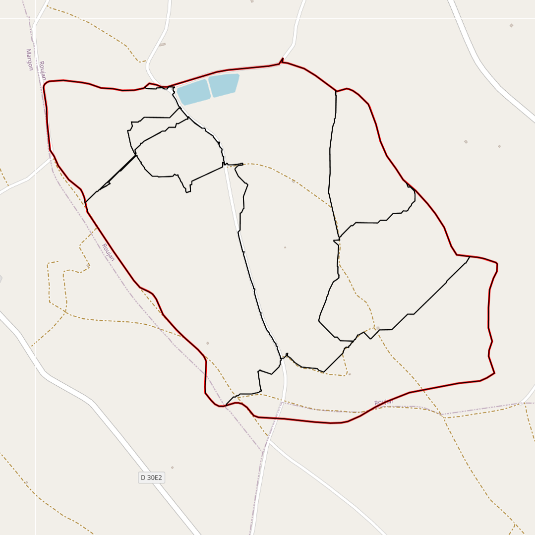
Contour map of the monitored sub-catchment areas (Roujan)
Simple
- Date ( Creation )
- 2006-01-27
- Date ( Revision )
- 2014-08-11
- Identifier
- roujan_sous_bassin_versa_20140811_150246
- Maintenance and update frequency
- As needed
- Keywords
-
- Keywords
-
- thesaurus_localisation_omere ( Place )
-
- Roujan
- UNESCO Thesaurus UNESCO Thesaurus ( Theme )
-
- Hydrology
- Hydrological networks
- Use limitation
- Utilisation libre sous réserve de mentionner la source (a minima OMERE) et la date de sa dernière mise à jour
- Access constraints
- Other restrictions
- Other constraints
- aucune restriction
- Classification
- Restricted
- Spatial representation type
- Vector
- Distance
- 5 metres
- Denominator
- 5000
- Metadata language
- fre
- Topic category
-
- Environment
- Farming
- Description
- Roujan
))
- Reference system identifier
- EPSG / RGF93 / Lambert-93 (EPSG:2154) / 7.9
- Geometric object type
- Surface
- Distribution format
-
-
ROUJAN : sous-bassin versant (rousbv12251_l93)
(
2014-08-11T12:00:00
)
- Specification
- Shape au format shp.
-
ROUJAN : sous-bassin versant (rousbv12251_l93)
(
2014-08-11T12:00:00
)
- OnLine resource
- Charter for the use of OMERE Observatory data ( WWW:LINK-1.0-http--link )
- OnLine resource
-
Georaphic layer of the Roujan sub-basins in ShapeFile format, downloadable via a ZIP archive.
(
WWW:DOWNLOAD-1.0-http--download
)
Georaphic layer of the Roujan sub-basins in ShapeFile format, downloadable via a ZIP archive.
- OnLine resource
-
roucnt21311_l93
(
OGC:WMS-1.3.0-http-get-capabilities
)
Geographical layer of the contour of the Roujan catchment area
- OnLine resource
-
rousbv12252_l93
(
OGC:WMS-1.1.1-http-get-capabilities
)
Visualisation of the geographical layer of the 5 sub-watersheds of Roujan
- Hierarchy level
- Dataset
Conformance result
- Date ( Publication )
- 2010-05-03
- Explanation
- Non evalue
- Statement
-
cf. fichier ROUSBV12251_l93.txt
Avec aml (ArcInfo) "bdhydro", et avec fossé roufos28351 + MNT 2m
GRID-CODE pointe sur TNODE_ (nœud terminal) de roufos28351
VERSDEV = regroupement des sous BV (f(GRID-CODE)
- Description
- ROUJAN : sous-bassin versant (5 stations); brut
- Feature catalogue citation
- File identifier
- 667f147c-2d0e-4512-a4e5-72dad02e87c2 XML
- Metadata language
- fre
- Character set
- UTF8
- Parent identifier
- Observation site of the Roujan's catchment (Herault / France) 1c37c878-e4cc-4137-8556-11561b4d91a1
- Hierarchy level
- Dataset
- Hierarchy level name
- Données géographiques
- Date stamp
- 2021-04-13T13:40:05
- Metadata standard name
- ISO 19115:2003/19139
- Metadata standard version
- 1.0
Overviews

Spatial extent
Provided by
